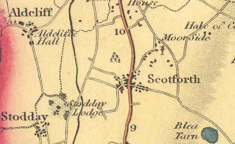
Scotforth village lies approximately two miles south of Lancaster centre, Lancashire, on the Preston to Lancaster road. It was ‘absorbed’ into Lancaster in the early 1900’s.
An enlarged portion of the 1890 O.S. map does not name the principal roads, but the prominent roads, reaching left and right, although only lanes at the time, are believed to have been known as East Road and West Road. They were most likely to have been given their current names of Hala Road and Ashford Road at the time of the village being incorporated into Lancaster in the 1900’s, there already being an East and West Road there.
This same map shows large parts of Scotforth covered in trees, which by further examination are revealed to be orchards. Some of these orchards were still in existence in the 1940’s and 1950’s. Close to my home, off Ashford Road, Uggle Lane held the entrance to several of these orchards along it’s western boundary. The lane ran south, giving access to fields in the vicinity of the present day Lawson’s Bridge, as shown on Hennet’s map of 1829. From that point, trace of the earlier lane can be still be made out, rising over the higher ground towards Stodday.
Indeed, Greenwood’s Map of 1818 suggests that, moving west from Scotforth Village along the present Ashford Road, the turn south into Uggle Lane may have been the primary direction.
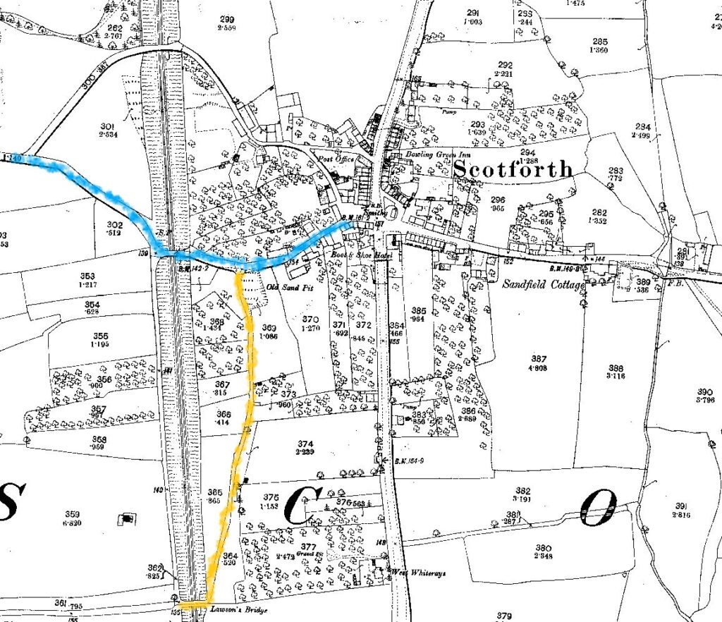
The arrival of the Preston to Lancaster Railway in 1840 cut through all of these orchards, giving rise to a further lane, Cinder Lane, being formed as an accommodation lane to the western portions of these orchards.
An examination of the Tithe Map of 1843 shows the extant of these orchards, and their occupiers, even after their bisection by the coming of the Lancaster to Preston Railway.
I don’t personally go back that far, but I still recall some of the older parts of Scotforth, no longer standing.
Although my parents first home after I was born in 1942 was the flat at Robert Gardner’s, builders merchants premises at Marsh Point at Lancaster, where dad worked, I have no memory of that, although I visited the place many times later in my teens and twenty’s. The buildings, part of an isolation hospital, have now been demolished, and the grounds until recently, used by Keyline Builders Merchants.
My first home I recall, was on Ashford Road at Scotforth.
Ashford Road ran westward from the Preston to Lancaster road, later enumerated as the A6, from Scotforth square. To the east ran Hala Road (pronounced Hay-ler), formerly called East Road, which after it crossed Scotforth Beck by way of a ford, then continued directly up over a short steep hill, after which it rose again, and after merging with Bowerham Lane, continued to the country east of Lancaster generally.
(Flooding events of the beck in 2020 have produced reports erroneously calling it Burrow Beck, even by the local authority, but as Alan Passmore’s histories on this site show, it has been known locally as Scotforth Beck since at least the early 1900’s. It takes the name of Burrow Beck on passing into the hamlet of Burrow, west of the A6 by the site of the former Scotforth Filter House.)
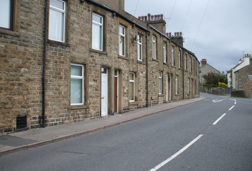
The house on the Portland Terrace part of Ashford Road, is in a row of terraced cottages; the earlier eastern section being visible on the 1890 map; later extended westward around 1898.
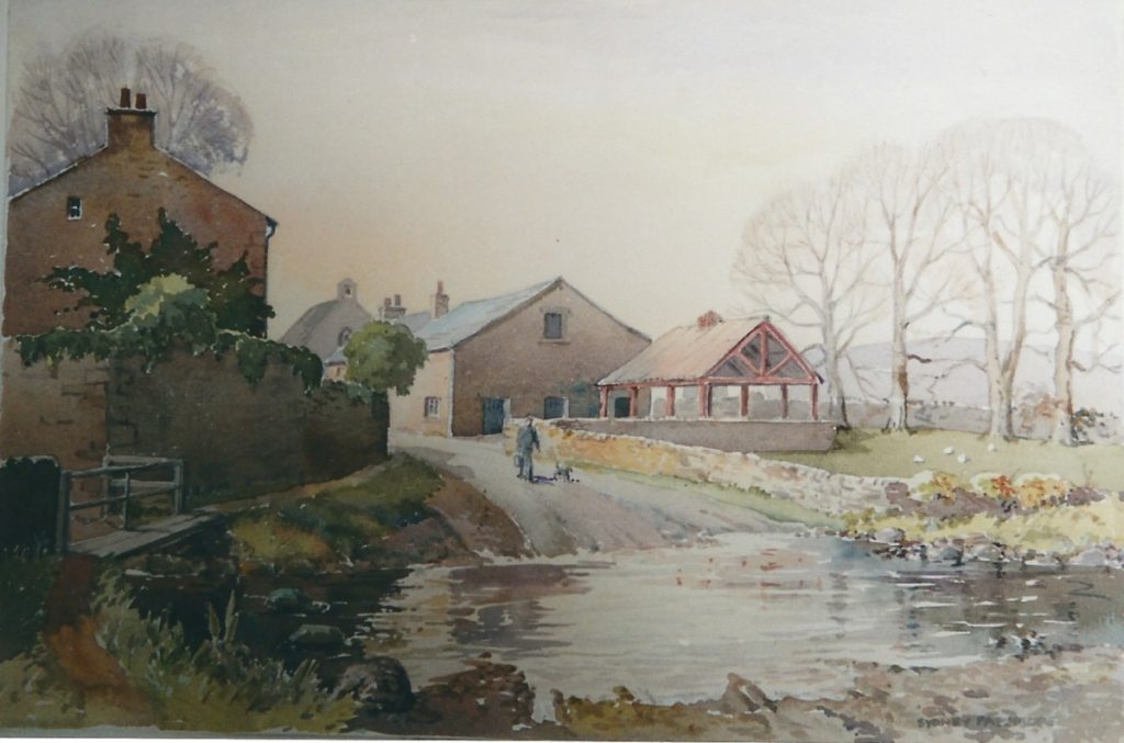
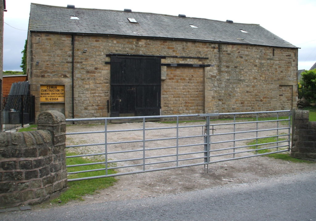
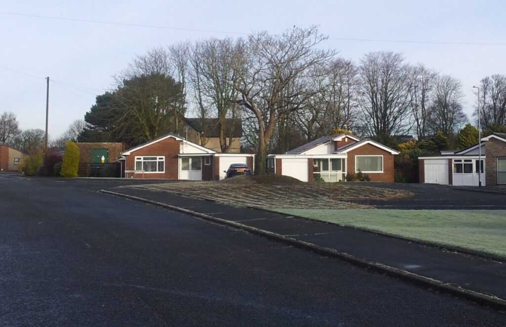
The road had the feel of a country lane, with a field opposite where three horses used to canter around. The field gate was at the corner where Uggle Lane branched off Ashford Road. The field had a high hedge, obstructing the view into the field from ground level, but from the bedroom windows was clearly visible, across to the white buildings of Uggle Farm. To the left (north east) of the field was a yard and a large barn, always known to my childhood friends and me as Fox’s yard. The barn is now used by Cowan’s Builders, of Greaves Road, Lancaster. The white farm building just visible in the photo above, Laburnum Cottage, would appear to be one of the oldest original buildings remaining in the village, dating from the mid 18th century. Historic England: 1298378
All the houses had front doors giving access to a very small hall, merely one door before another door leading into a small front room. From the front room, a doorway gives access to the back kitchen. Initially the kitchen had a black cast iron fireplace and oven built into the party wall. A back door leads out into an enclosed yard surrounded by a high stone rubble wall. In the kitchen, to the side of the back door is a further door and steep stairs leading to the upper bedrooms. Directly opposite the head of the stairs was a small bedroom, whilst turning to the left the ‘master’ bedroom was over the kitchen, with a ‘middle’ bedroom down a short corridor and facing the front of the house. This bedroom had a small iron fireplace, lit on more than one occasion when I or one of my brothers slept there through childhood illnesses. There was no bathroom in these houses at this time. Each house had an outside lavatory at the end of the yard. The lavatory’s each had an adjoining Victorian midden, although all were being used as outhouse, coal houses or tool sheds by this time. Running down the back of Portland Terrace is a ‘back’, or lane giving access to all the properties, emerging at the lower end of the terrace, opposite the end of Uggle Lane. Across the back lane, each house had a garden about 30 feet long, all well tended. Their rear boundary’s overlooked a large orchard, principally of damson trees, extending from the rear of ‘Oaklea’ in Scotforth Square, westward to the railway cutting. The northern boundary of the orchard was the narrow stony lane of Piccadilly.
My earliest memories are of a spartan home, initially with very little furniture. Although I don’t remember the birth of my brother Jeffrey in 1944, one of the first memory’s I have of him is of him being in his pram in the back yard, and of my pushing the pram out through the back gate one day. There was a high step down, which resulted in the pram tipping over forward, complete with Jeffrey in it!
Although my father was still ‘away at the war’ I was not conscious of his absence, but I do remember his presence on at least one occasion in Naval uniform. He was not discharged from the Royal Navy until 1946, serving latterly in the Far East.
My first school was Scotforth School under the headship of Mr Todd, a tall thin man who to me always had the look of ‘death’ about him. The reception class teacher was Mrs Airey. Later classes came under Mrs Osliffe (who’s age never seemed to change, on seeing her near her home in Bowerham Road on several occasions many years later), Mrs Broadfoot and Mr Evans. ‘Higher’ junior classes were accommodated in Scotforth Parish Hall where I principally remember Miss Tooth, and Mrs Whitehead (I later knew her son David, an electrical boffin who later went on to work for Ferranti and later, to senior positions at Racal and Vodaphone. (AP))
After my mother took me to school for the first few days, I seem to recall I was left to find my own way along that long Scotforth Road by myself. My father worked all his life, apart from his wartime naval service, for Robert Gardner who ran a small empire comprising of a builders merchants, a coal merchants (from Green Ayre station) and a small number of coasting vessels. Around this time he lived in a large detached house at the junction of Scotforth Road and Bowerham Road called “Beaufoy”. On occasions, on my way to school, I would see him backing his car, a black Austin Sheerline, out of his garage, and across the A6 Scotforth Road, turning to face into town, which would be a high risk manoeuvre in todays traffic! On a couple of occasions, I was honoured with a ride for the few hundred yards to school.
Opposite Scotforth School stands a small row of shops. Back in my childhood, the outstanding shop was Mr Keefe’s sweet shop. Next door was a fish and chip shop where a bag of chips was about threepence ha’penny. One street back from the school is Emerson Street, where in my early days stood a brick and concrete air-raid shelter. The footprint of the shelter remained in the roadway long after the shelter was demolished.
Another once familiar site was the pavilion on Barton Road playing fields. The large black wooden pavilion lay on the southern edge of the field. It would probably have accommodated about sixty people under cover on its tiered seating, with a store room underneath where goal posts and corner flags were kept. It was regularly used by school sports supporters for both changing and viewing, and no doubt by young courting couples ‘out of hours’. There were occasional incidents of damage by little arsonists, but with the increase in the youthfull population of the ‘new’ Hala Estate in the 1950’s, eventually the inevitable happened, and it was burnt down, never to be repaired. Sadly, no trace of the pavilion now exists.
Somehow, at an early age, I found myself attending Sunday School, which was held in a chapel adjacent to a farm house on the north side of Hala Road. It was a simple room, with an elevated section at the north end. A plain wooden floor, with chairs and benches set around the perimeter. The preacher I remember was an elderly (to me) Tommy Close.
My paternal grandparents lived at ‘The Forge’ just off the square in Scotforth. Grand-pop James Reay was the village blacksmith and horse shoer, and always to me, an interesting character, with all his gadgets to see in the nearby smithy. Although by this time, semi retired, when I called, he always seemed to doing something. A very early memory is of grand-pop french polishing a table, although I didn’t know that that was his task at the time.
Another constant in the village was ‘blind Jack’, frequently seen standing at the edge of the square on the Ashford Road side against the old ‘Roman’ milestone, (since removed; what happened to it?) { A local newspaper article of 1952 recently discovered, describes the stone as a plinth to a sun dial.}Always dressed in a beige gaberdine mac and cloth cap. He would recognise some passing folk just by their footsteps and greet them by name. He was always just ‘blind Jack’, and although he lived on ‘our’ road, It wasn’t until recently that I found him to be John Foster, who in the 1939 Register for Ashford Road was described as a ‘Brush Maker’..
The village was almost ‘self sufficient’ in that there was, a busy Post Office cum Newsagent and general stationary store, from which I had a paper round circa 1950. To the north of the Post Office, across the mouth of Picadilly where there is now a small car park, stood a Green Grocery shop. Behind that, in Picadilly, stood Hall’s Dairy; the buildings now converted to housing. Across Scotforth Road on the east side stood the old Bowling Green pub. In the same terrace of buildings was ‘Parkinsons’ Sweet Shop, with its step down into the premises. Continuing south, with its door on the corner of the block was Dawson’s general store, locally called ‘Gaks’, really nothing more than a porch into the property, with items stacked on either side. Any more than two customers resulted in a queue outside. Anything requested that was not immediately to hand sent white haired Mrs Dawson scuttling off into the dark interior to produce the required goodies. Across a little alleyway stood a red brick building housing a Cobblers business. In earlier times, a clock was affixed high up on this red brick wall, which resulted in older generations of Scotforth folk referring to this building as the ‘Town Hall’. The iron ladder used to reach and wind up the clock was for many years stored in the back of grandpop’s Smithy.
Scotforth Road through the village could be a busy road in the 1950’s, before the building of the motorway. All manner of traffic passed this way. Occasional military convoys drove through, making for Bowerham Barracks, and even one occasion I recall, marching troops going that way.
A cousin, Pamela, related the tale of, whilst visiting our grandparents at the Smithy one day, she saw nana Reay staring unusually intently out through a window to the road outside. On asking her what she was looking at, nana replied in a dead pan tone, “an elephant.” Sure enough, a circus was coming to town!
Great exitement was caused when occasionally very large loads such as boilers or transformers would be driven through, with motorcycle policemen clearing the way, probably heading for Heysham Harbour. As motor traffic slowly built up after the wartime and rationing period, things became much busier. At this time, with only the one (Skerton) bridge crossing the river, long queues of traffic would build up northbound, far outstripping todays conception of heavy traffic. Notable events such as the autumnal Blackpool Illuminations brought vast convoys of coaches through Scotforth, carrying Glaswegians south for their annual binges. Their return journeys produced long lines of crawling coaches, backed up way out towards Galgate. The coaches contents, no doubt well lubricated from their many ‘refreshment’ stops on their way up the A6 produced showers of ‘surplus’ coins rained down on the assembled kids in Scotforth Square.
In the 1960’s, many of the properties around Scotforth Square, not having indoor toilets or bathrooms, were listed for ‘slum’ clearance. Those properties to the south west, and north west side of the square in Ashford Road fell into this clearance, although a recent article elsewhere in March 2021 suggests that occupiers of the terrace on Scotforth Road towards the post office somehow appealed against the order, and were reprieved. They remain, all now having the necessary ‘facilities’. ‘The Forge’ and it’s adjacent cottages were surplanted by what is now ‘Rowley Court’, a masonic institution; although originally built as a Unitarian Church; itself a replacement for the unitarian church demolished in the clearance of St Nicholas Street in the centre of Lancaster, circa 1960.
One then came to the east side of Scotforth Square. It was here that Lancaster’s No 1 (Marsh) and No 3 (Beaumont) buses turned around before heading back to the town. Queues of folk waited here at the side of the Boot and Shoe Hotel for the maroon and cream buses of Lancaster City Transport.
Hala Road, running east from the square, in my early childhood, passed between several farm buildings and orchards, to the ford over Scotforth Beck, after which it rose straight up and over Hala Hill, steeply down a dip, before rising again to meet with Bowerham Lane where, at the junction, stood alone, Hala Cottage, site of several related family gatherings.
In about 1955, ‘improvement’ came to Scotforth, starting with a large sign board being erected alongside Hala Road facing oncoming traffic – what little there was. A simple white sign, with the name ‘Gilbert Ash‘ emblazoned across it in large black letters. Walls were knocked down, trees grubbed up, and a road built running south off Hala Road, almost opposite the Sunday School building. Here, what became a ‘standard’ style of semi-detached houses grew up, set well back from the road, allowing a small open plan garden to the front, as well as enclosed gardens to the rear. There was space alongside the footpaths for trees to be planted, in due ceremony by the local sunday school pupils, including yours truly.
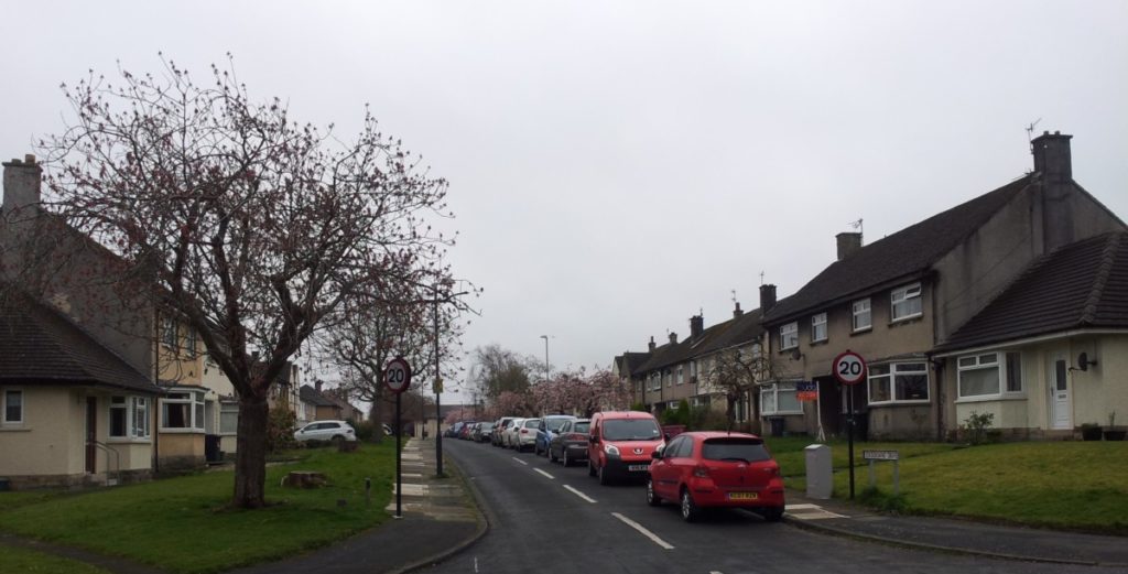
This, the first road on the first of the post war housing estates in Lancaster is named Cockersands Drive. At the time of building, private ownership of cars had not yet expanded from wartime levels, and as can be seen here, no provision was made for off-street parking. The estate expanded over the next few years, across the now culverted beck, and the direct run up the hill eased by taking the road around a loop, called Hala Square. Many of the roads are named after local hamlets and villages. Some off-street parking for the houses built later, to the east of Scotforth Beck, was created in series of garage compounds, but this barely makes a dint with the current level of car ownership.
Over the top of Hala Hill, the road dropped down into a deep hollow before rising up again to meet Bowerham Lane alongside the once isolated Hala Cottage. In the hollow stood a large post and iron clad barn, scene of annual family bonfires hosted by a branch of the Cousins family, related to my family by marriage. As the Hala Estate expanded, a causeway was created across this hollow, giving almost level access to Bowerham Lane, and a later housing scheme, Greenacre Court, has almost hidden Hala Cottage from view.
Further north along Bowerham Lane, adjacent to the large house, Hala Carr, owned by Horace Cousins, now buried under Goodwood Road and Goodwood Court stood Cousin’s Dairy, instigated in the mid 1930’s, where milk was brought in from surrounding farms by milk kits on flat bed lorries, and bottled for onward delivery. At peak times, the noise was quite deafening within the plant. As a lad of about 10, I would occasionally give a hand to unloading the empty milk kits off the back of a lorry, dragging them onto the loading bay, hand by hand. On one occasion I gave the usual quick flick of the handle to get the kit to fly across to the loading bay, but mid flight it dawned on me that this particular kit wasn’t empty! It landed with it’s base rim right across my foot; about half a hundredweight of full milk kit. I ended up in the local hospital, but survived with just a walking stick for about a week.
Shortly after building on the Hala estate got underway, development started off Ashford Road, with the building of Ashford Close by local builder F W (Freddie) Nelson. This provided an alternative playground to us local lads, with running around in the footings, playing on the sand heaps and tinkering with the large mortar mixers after the workmen had left for the day. Health and Safety; never heard of it!
As children, our play area was ‘the back’ of Ashford Road, but also, Ashford Road itself, and Fox’s Yard, ungated in those days, from where – in autumn – bats darted up and down the road, no doubt roosting in the barn. Unlike today, through traffic was almost non-existant so playing in the road was a normal accepted pastime. ‘Footy’ in the street, tricycles and later- bikes allowed us to get a bit further away. The ‘circuit’ of Cinder Lane, with it’s various orchards and it’s market garden, returning by way of Uggle Lane, and further orchards provided a pleasant walk with parents, or an escape from them! Wandering even further, I recall expeditions with jam jar and finding newts in the tarn near the railway just south of the village.
My own forte for a while was pedalling like mad, from the top of Ashford Road, left into Picadilly, riding right along the narrow stony track, past the whitewashed barn below the Potter’s house, over the railway bridge and turning left onto the footpath parallel above the railway embankment, to Hibbert Terrace, back to Ashford Road. This path is now sadly overgrown and barely passable even on foot. It previously gave access to the Royal Albert Hospital for the staff who lived nearby. A little later, older lads i.e., 15 or 16 year olds from further away discovered the ‘circuit’ of Cinder Lane and Uggle Lane, and (slightly) more organised cycle ‘racing’ took place, with home made field telephones at each of the two bridges, connected via crocodile clips to the wire fencing along the line, giving position reports, a la Isle of Man TT. One of this systems instigators, David Whitehead, went on to work for Ferranti, and later Racall – Vodaphone.
Train spotting was an inevitable past time for some, with majestic steam hauled trains passing along the adjacent line, long heavy mixed freight trains as well as some of the ‘names’ express passenger trains such as the ‘Royal Scot’ and ‘Midday Scot’. Southbound freight trains were occasionally seen being ‘banked’ up the Ripley incline, with the ‘banker’ dropping back into the sidings of the original Lancaster station off South Road, now the car park of the Royal Lancaster Infirmary. In the early 1950’s, modernity arrived with the LMS, and later British Railways, Derby built diesel electric locomotives 10000 and 10001. Living so near to the railway, the sounds of trains became normal background noise, until it stopped, and one wondered what was up? An occasional lament from a fog man’s horn signalled a warning note to platelayers re-laying heavily used track.
In my childhood period, I recollect milk being delivered to the house by horse and cart, with the milk being ladled out from churns by dairyman Mr Hall from the dairy on Picadilly. Another horse and cart home delivery was fruit and vegetables by Billy Mashiter. Pedlars going from door to door were a common feature of the time. One that I recall calling on us was, to me, a tall Sikh who had a large brown suitcase. My father always admitted him to the house, although I don’t know if he actually bought anything, but father had spent some time in India in his wartime naval service and was happy to swop tales with his Sikh friend.
With a third child arriving in the family, my parents were obviously finding our Ashford Road house somewhat cramped. My father had already carried out a loft conversion, but we were still without a bathroom and inside toilet. Although never explicitly discussed with us children of course, It was obvious that mum and dad were looking for somewhere else to live, with frequent trips out in our blue Triumph Mayflower looking at large houses; one plan being to split and share with Uncle George and his family. This wasn’t quite what eventually happened. The end result of the searching was the purchase of a piece of land at Langthwaite, on the extreme north easterly edge of Scotforth, and the self build of a couple of vastly different bunglows over a period of a couple of years around 1960. Although our northern boundary wall was the actual boundary of Scotforth Parish, it rather ended my relationship with Scotforth Village.
Jan 2021.