By Gordon Alexander Passmore
To solve the problem of vehicular congestion in Lancaster’s narrow streets and the infamous ‘bottleneck’ of the Lune crossing at Skerton Bridge, the authorities made plans for an entirely new road, built over agricultural land to the east of the city. The southern end would start from a new roundabout on the A6 trunk road at Hampson Green, south of Galgate (now Junction 33), continue north for eleven and a half miles to a similar new roundabout north of Carnforth (now junction 35A). Lancaster, Morecambe, and Yorkshire Dales traffic would exit onto Caton Road (A683), near the new Lune Bridge, now junction 34.

The new road was designed specifically to be ‘a motor-way’, with restricted access, pedestrians, cyclists and pedestrian controlled vehicles would be excluded. Thus, catering for fast traffic flow; this modern style of road management being like the famous ‘Autobahns’ developed in pre-war Germany. Planning for the Preston By-Pass had begun in 1937, with a delegation of Lancashire County Council officers visiting Germany in 1938. However world events intervened, so it was only in 1949 that the program could be re-started.
Lancaster’s new By-Pass later formed an essential ingredient of the UK’s motorway network, which in the early 1960’s was still under consideration by Parliament. As this network evolved in that decade, the Lancaster By-Pass was extended south, joining the Preston By-Pass completed in 1958, immediately prior to work starting at Lancaster. Most of the work force moved from Preston as the work opened at Lancaster. The combined unit now formed a continuous section of the M6. Further sections were added in quick succession, extending the network to join with Britain’s first major motorway the M1, southeast of Birmingham, by the end of the 1960’s.
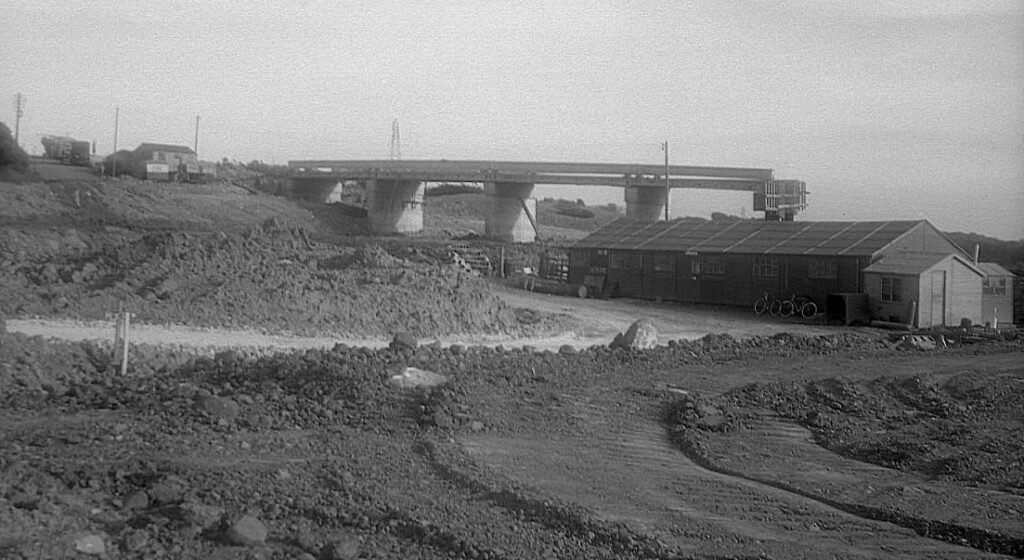
The principal contractor for the Lancaster By-Pass was Sir Lindsay Parkinson & Co. Ltd., on behalf of Lancashire County Council, with a tender cost of £3,186,388. The total forecast cost was £3.75 million. The land reservation was 112 feet wide, which allowed for the initial construction of two asphalted carriageways 24-foot wide giving two lanes for traffic each way. The central median strip was broad enough to allow for future development of a third lane each way. The project included twenty-seven bridges of which the Lune Bridge would be the main construction feature and costliest part of the project. Built of reinforced concrete it has a graceful single 230-foot span over the river.
Earth-moving equipment and machinery was mostly sub-contracted from plant-hire companies including the Blackwood Hodge subsidiary ‘Euclid Wagon Hirers’. Parkinson had their own plant yard, dump trucks, excavators, cranes and concrete equipment used in the construction of the Lune Bridge.
As a teenager growing up in Lancaster at that time, I was fascinated by the scene offered to me of construction machinery tearing up the countryside! It was exciting, something new was occurring in our midst. All Lancastrians knew of the almost daily traffic snarl-ups in town, worsening every year since about 1950, as more people could afford the luxury of a motor car. Holiday times saw Lancaster’s roads clog up, with overflow from the A6 route through town. A one-way system was developed; north-bound traffic from Scotforth travelled down South Road to Penny Street Bridge, King Street, China Street, past the Bus Station, Parliament Street, Green Ayre Station then turned left over Skerton Bridge, through Beaumont on Slyne Road to Bolton-le-Sands, Carnforth and the north. South-bound traffic entered along Slyne Road, Skerton Bridge, turned right into Parliament Street, North Road, Stonewell, Great John Street, Dalton Square, Thurnham Street, Penny Street Bridge, South Road etc. Other variations followed, including south-bound traffic turning left off Skerton Bridge into Caton Road, going around the Kingsway Baths & Corporation bus depot, via various ‘back streets’ into Stonewell. With normal weekday traffic these routes coped well, as most ‘workers’ travelled to and from their factories by special bus services designated “W” on Lancaster Corporation buses. Sunday evening was often a problem, people returning through the city after a day or two in the country. I remember long queues on Morecambe Road, waiting for the lights at the ‘T’ junction in Skerton. Also, on Caton Road, waiting for traffic to clear the lights at North Road/Stonewell and Dalton Square, often in the dark.
Our new By-Pass would solve all these problems – right?
Well, initially it did. Then Lancaster moved on too; forced by the huge societal change taking place across Britain in the latter 1960’s, with the decline in manufacturing, coal mining, heavy industry, and the use of public transport. Lancaster changed from a manufacturing town to a university town in a relatively brief time. Our new By-Pass, encouraged the rapid spread of motorways, increasing traffic to the Lake District, the Yorkshire Dales and Scotland. So much so, the original two-lane motorway had to be widened to three lanes only five years after opening.
It should be noted; that at the time the By-Pass was opened in April 1960, Dr. Beeching had not lodged his infamous plan for ‘Reshaping British Railways’. Lancaster enjoyed a thriving railway network. As well as Lancaster Castle Station on the West Coast Main Line, with connections to Morecambe, Heysham Docks and the petroleum refinery, Green Ayre and Glasson Dock. There was a second station and steam locomotive depot at Green Ayre, near Skerton Bridge. Green Ayre Station provided access to the ‘Lune Valley Line’ Heysham to Wennington, bringing regular traffic from Leeds – holiday traffic to Morecambe and boat trains to Heysham for Belfast and the Isle of Man. Some freight was still brought into Lancaster from Glasson Dock by steam train! Due to public demand, a third station was built at Scale Hall to serve commuters on the electrified Green Ayre to Morecambe Promenade line. Sadly, it had a short life of barely ten years, ending when the entire line closed in January 1966.
As well as the rail network and its own City Corporation bus service, Lancaster was connected within its locality by a fleet of Ribble buses, serving most towns and villages with at least a daily service. Ribble and its subsidiary Standerwick operated express services to destinations further afield, such as Keswick, Carlisle, Blackpool, Manchester and London.
Skerton Bridge was the only road crossing over the Lune in Lancaster, Greyhound Bridge was rail only, Halton Bridge was restricted to local traffic, the next option was further up at Crook O’ Lune, Caton.
In recent years, a second Lune Bridge was built with an extension for Heysham bound traffic (A683 – the Heysham to M6 Link). There are ongoing proposals to construct an additional road south of the city between Hampson Green and Bailrigg to accommodate a proposed housing development, as well as talk about the need for a third new Lune crossing west of the city.
With Dr. Beeching and British Railways long gone, the latter sadly missed by many, with Climate Change our immediate challenge, it is time to reconsider the future of transport and public access. What do we really need it for, who needs it, and can we adapt what we have to better serve the entire community. The financial cost for new roads and rail (HS2) is enormous and environmentally disastrous. With some new thinking, the recently abandoned HS2 North Project may offer advantages for the North-West – a return to local fast light rail along long abandoned corridors, for freight and passengers? Alternatively, routing HS2 from Fleetwood to Barrow-in-Furness over the once proposed ‘Morecambe Bay Barrage’ then via the Cumberland Coast into Scotland – perhaps!
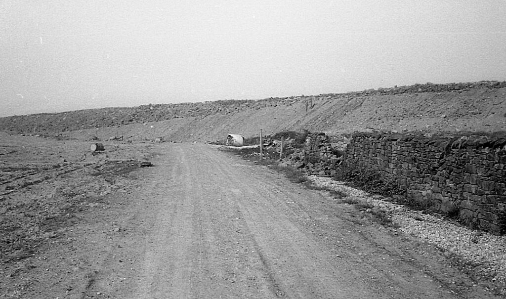
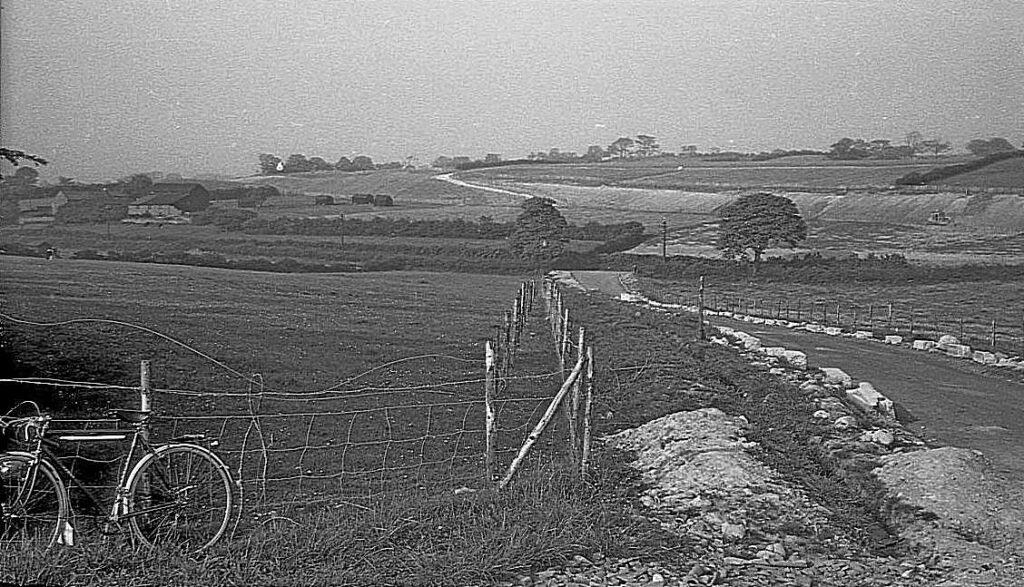
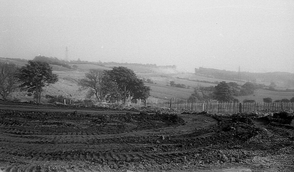
A section of the Lancaster By-Pass was built within Scotforth Parish, between Bailrigg and Newlands. The area was easily accessible to me, being just a few minutes on my bicycle from my Bowerham Road home. I took my camera and began photographing the huge earth moving machines at work. Some drivers noticed me on subsequent visits and asked me to take their photo. I was happy to oblige, for which they gave me pocket money, more than enough to buy more film! By that time, I had just started developing, printing and enlarging photographs at home. I could deliver their prints on my next site visit – sometimes the following day! It was an exciting time for a fifteen-year-old and a change from trainspotting! Not only did this enterprise establish my new hobby, but it also opened the idea to me of working in the construction industry in later years.
I experimented with several types of film – there were many ‘failures’, which did not seem worth dealing with at the time. However, I preserved the negatives, now with the aid of modern technology, I can present some of them here.
A selection from the photographs taken in summer 1959.

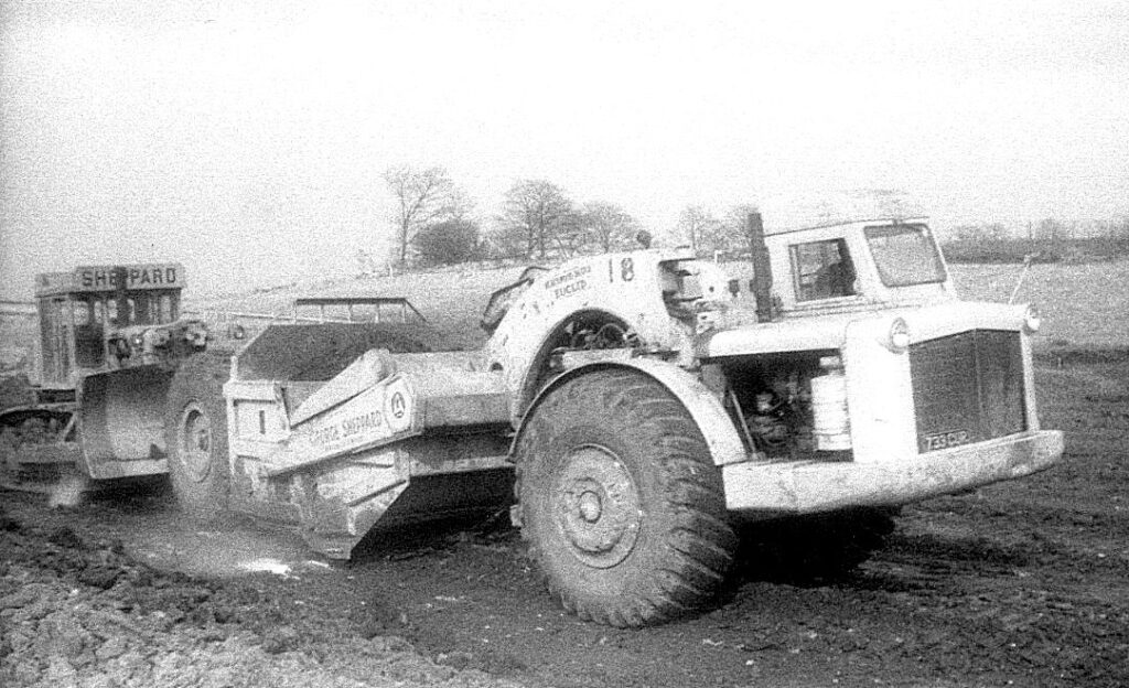

Although these ‘motorised’ earth scrapers were new to me, they were new to the UK construction industry as well. The two scrapers shown here are prototype Euclid TS-14’s, manufactured by Blackwood Hodge in Northampton, England, undergoing rigorous field trialling. According to records the TS-14’s were not released onto the market until mid-1960, after the Lancaster By-Pass was completed. Their appearance at Lancaster attracted unwarranted attention, one unit was stolen and, according to an eyewitness, was
last seen heading south down the A6!
Earth scrapers were not a new idea; various forms had been used in land clearing for roads, open-cast coal mining and airfield construction, attached to a bulldozer, earlier versions were even horse drawn!


Here are some of the mighty characters who drove those machines:
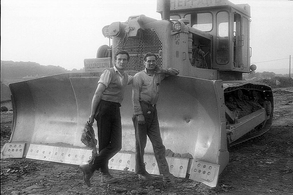


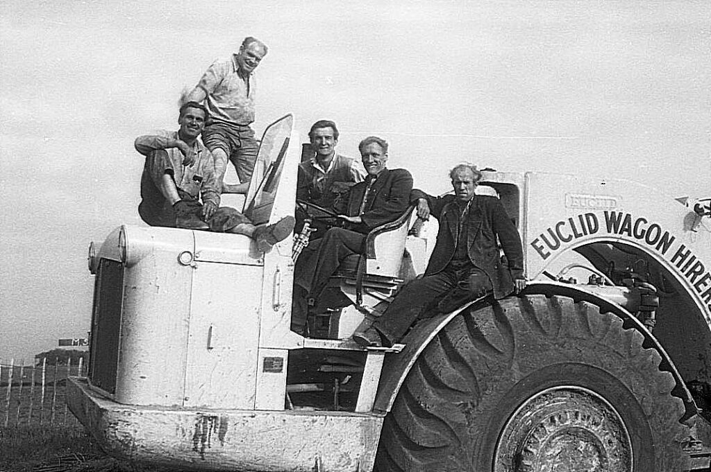
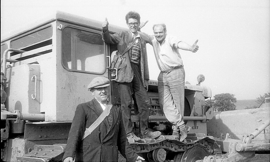

Big Jim encouraged me to take his photo when he spotted me with my camera. He wanted a photo to show his wife and family; this was a time when few workers carried a camera. It was an era before ‘occupational health and safety’ took control in the construction industry; hard hats, safety clothing and footwear are not seen in these photos, the men wore their own clothes and gear!
……….. construction continuing……..